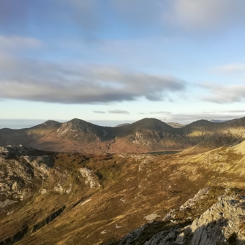
Tucked away in the wild beauty of Connemara, Benlettery is one of the southernmost peaks of the Twelve Bens mountain range in County Galway in Ireland. Though often overshadowed by its higher siblings, Benlettery offers hikers an accessible and rewarding climb. The summit rewards with panoramic views of Ballynahinch Lake, the Atlantic coastline, and the rugged peaks of Connemara. Whether you’re a casual hillwalker or seeking solitude in nature, this hike is a hidden gem worth exploring.
The Twelve Bens
The Twelve Bens is a mountain range in Connemara National Park in County Galway in the western part of Ireland. The size of the Park is about 2,000 ha (4,900 acres) and it consists of mountains, bogs, heaths, grasslands and forests.
“Ben” is an anglicised form of the Irish word binn, which means peak. Interesting fact, that it seems nobody knows which are exactly the twelve peaks. But, the most common list of the twelve peaks in question are the peaks with an elevation above 500 metres in the core range. Moreover, that are not considered subsidiary peaks, the ones that have been traditionally noted as peaks on historic maps.
So, originally, these are the twelve bens that are counted: Benbaun, Bencorr, Bencollaghduff, Benbreen, Derryclare, Bengower, Muckanaght, Benfree, Bencullagh, Benbrack, Benlettery and Benglenisky. Overall, there are 38 identifiable peaks in the wider Twelve Bens range that have bigger elevation or height than 100 metres (328 ft).
The core massif of the Twelve Bens mountain range has deep glaciated U-shaped valleys. Besides, the groups of Bens lie in a horseshoe formation around it. Furthermore, it can be split into three sections: Southern, Central and Northern Bens. Benlettery is one of the peaks of the Southern Bens.
About Benlettery
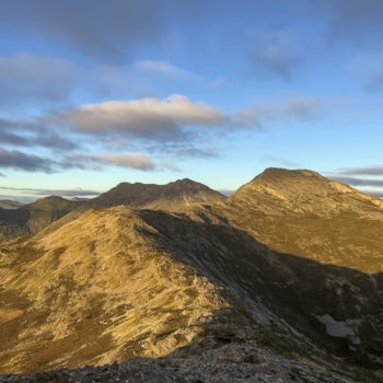
Benlettery means “Peak of the Wet Hillsides” in English. It is the southernmost peak of the Twelve Bens mountain range. This mountain is the 11th tallest of the core massif, and it is 577 metres (1,893 ft) high. Benlettery is one of the six Bens that form a horseshoe around the valley of the Glencoaghan River. This Glencoaghan Horseshoe is considered one of Ireland’s best hill-walks.
Benlettery is connected to the range by a high northerly ridge to the peak of Bengower. Bengower is 664 metres (2,178 ft) high, it is the sixth tallest among the mountains of the original, core massif. This ridge forms a fork, which also connects the neighbouring Benglenisky to Bengower. Benglenisky is 516 metres (1,693 ft) tall, which makes it the smallest of the twelve. You can hike the three bens: Benlettery, Bengower and Benglenisky in one go.
We wanted to hike all the three, but we went in November and started the hike late. Unfortunately, we didn’t have enough time, so, we only did the Benlettery hike.
The Benlettery hike
The difficulty of the Benlettery hike is moderate. The length of the hike is about 6 km round trip (depending on route), and it takes about 4 hours. Or a bit more if you get lost, like we did, but more about that later. The best time to go is from spring to early autumn on a clear day. Definitely not when the sun sets early.
How to get there?
- By car: We stayed in Galway and drove from there. Renting a car is the most convenient. It took about 1-1,5 hours to get there. From Clifden it takes only about 15-20 minutes.
- By public transportation: If you want to use public transport, take the bus 923 from Galway or from Clifden, if you stay there. You shall get off at Canal Bridge, from either direction. But you have to walk about half an hour to reach the starting point.
Trailhead to foothill
The trailhead is at the Benlettery Youth Hostel. If you drive, you can leave your car in the parking lot in front of the hostel. This is your starting point. You shall start your hike up next to the hostel. Please note, that there is no official marked trail.
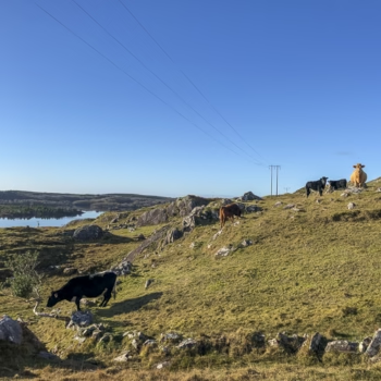
As you go upwards, you will find yourself on sheep-grazed grass. Besides, you will meet several sheep and cows on the meadows. Some of them are friendly, some of them are not. Soon, you will find a low wire fence, hop it or pass through a metal sheep gate beside the forestry. Once you leave the last trees, strike directly for the broad, grassy ramp with soft bog patches ahead.
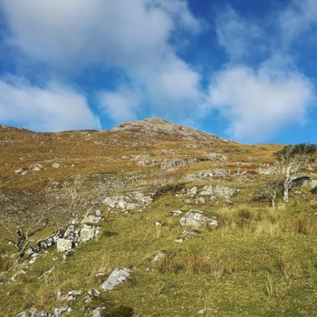
Foothill to climbing the ridge
The ascent will be steep, gradient kicks up sharply. Although the ridge looks closer than it is, pace yourself. Sip water, sit down on one of the rocks and enjoy the views. Use zig-zags to lessen the strain on your knees.
Skirt left of the rocky gully, the rock offers firmer footing than the boggy patches. Stay on the grass-rock seam; veering too far right leads into deeper bog. After rain the ground is springy and could be sponge-wet. Furthermore, watch for hidden peat holes.
Final summit push
The grass gets thinner and the terrain becomes rocky. Wind usually picks up and the temperature can drop a few °C vs. the trailhead. You shall follow the signs of the rocks. A series of knee-high stone cairns will guide you and mark the way to the summit.
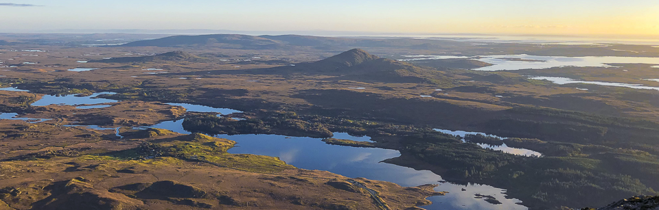
From the top you will enjoy the 360° panoramic views. If you had enough of the view and took a bunch of scenic photographs, you can continue your way towards Bengower. Of course, if you have enough time. Or you can go back on the same route as you came.
Tips for the Benlettery hike
As I told earlier, we only hiked Benlettery, so, we went back. The reason is, because the sun started to set when we reached the top. So, we had to make most of our descend in nearly complete darkness. If you happen to find yourself in a similar situation, I have some advice for you.
Have a headlamp or flashlight, your phone or something you can light with.
You will see a little gorge with a tiny stream on your way up. When you descend, make sure it is on your right. If you find yourself on the left of it on your way down, you have to go back up and get around it. This is where we got a bit lost, and we had to go back up in the darkness.
If you try to find your way down, take your look a bit farther. You will see the lights of the hostel, albeit faintly. Keep going in that direction and you will be alright.
To avoid getting into a similar situation, start early, give yourself plenty of daylight. Moreover, check the weather before setting out. Avoid hiking in poor visibility or strong winds. The views are the highlight, dark and foggy conditions can make navigation dangerous.
As there is no marked path, basic navigation skills are helpful. Follow ridgelines and natural landmarks. Besides, watch your footing. The descent can be slippery, especially after rain. Take your time and use poles if you have them. And of course, take your litter with you, and leave no trace.
What to pack for the Benlettery hike
While Benlettery is not the most demanding of the Twelve Bens, it’s still a remote and rugged hike, so, being well-prepared is essential. Here is what to bring:
- Sturdy and waterproof hiking boots: the lower slopes are grassy and can be boggy, so waterproof shoes are essential. While the upper sections are rocky, good ankle support and grip are also important.
- Waterproof jacket and trousers: Connemara weather changes quickly.
- Warm layers: even in summer, the summit can be windy and chilly.
- Backpack: a small daypack is perfect for carrying layers, food, and water. There are no services or water sources on the trail. Bring at least 1–1.5 litres of water and energy-rich snacks.
- Offline navigation tools: bring a downloaded offline map (such as Maps.me or AllTrails) or a printed Ireland hiking map. There is no marked trail, so route-finding is essential.
- Sunscreen and hat: on clear days there is no shade on the trail.
- Hiking poles: helpful for the steep and uneven descent, especially in wet conditions.
- Headlamp or flashlight: if you happen to find yourself in situations when darkness kicks in.
- Phone or camera: for capturing the incredible views over Connemara, Ballynahinch Lake, and beyond.
Benlettery might not be the tallest peak in Connemara, but its dramatic scenery and relative ease make it a perfect introduction to the Twelve Bens. With few crowds and unbeatable views, this short but satisfying hike offers a wild taste of Ireland’s natural beauty.
Have you hiked Benlettery? Or the three Bens in one go? What are your experiences?
If you are curious about other hiking routes in Europe, check out further blog posts here.